ABALOBI
Satellite based Coastal Hazard Assessment for Sustainable Economic and Tourism Development
Project Lead: SatSense Solutions
Support: Received mentoring, training and financial support from the second cycle of the Ocean Resilience Innovation Challenge (ORIC), that was financially supported by Swiss Re Foundation and the UK’s Blue Planet Fund
Location: Sunderbans, India
Financial Innovation: Data analysis and modelling quantifies risk of coastal erosion and flooding, enabling insurance companies to develop new products
Summary
By using satellite technology SatSense Solutions carries out remote imaging and data collection and combining it with geospatial analytics to address the risks and challenges of sustainable tourism in the Sunderbans area. The Sunderbans is a low-lying, densely populated area with low average income per household. It is prone to typhoons and flooding, relying on the receding mangrove forest for protection.
The ORRAA-backed project quantifies the risk of coastal erosion and flooding at a local level, providing mitigation options for local communities, property owners and developers and enabling insurance companies to develop and design new risk transfer products.
Challenge
Sundarbans is the largest mangrove area in the world spanning the Padma-Brahmaputra delta between India and Bangladesh in the Bay of Bengal. Although it covers an area of 10,000 km² I the area is subject to mangrove de-forestation for construction, fuelwood and the wood pulp for industry.
Sundarbans has a population of over 12 million people, 40 per cent of which live below the poverty line and 13 per cent officially classified as the “poorest of the poor”. [‘Reaching the Unreached in Sunderbans’, Dr Asim Sil, published 10 February 2017, Community Eye Health Journal]. The area is underdeveloped and needs sustainable inward investment and the employment opportunities that sustainable tourism can bring. Without this investment, pressure on nature will increase, leading to additional destruction of the mangrove forest, more damage, less sustainable tourism, and an expected increase in migration for those in search of employment.
Solution
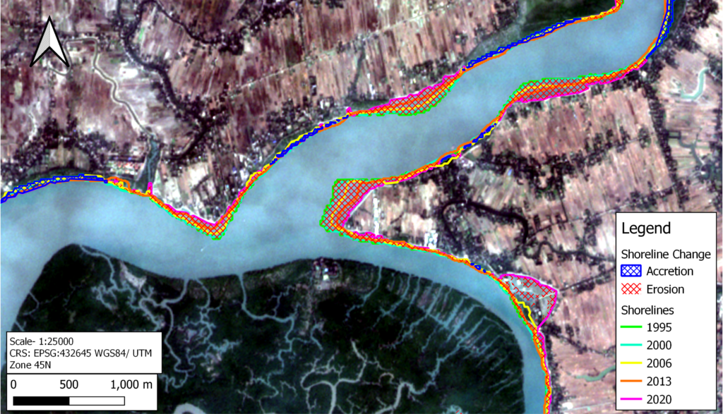
SatSense Solutions’ Sundarbans project uses satellite data to forecast and evaluate coastal erosion, inundation and eutrophication (harmful algal blooms that de-oxygenates the sea which results in fish and other sea creatures dying).
The project has analysed and modelled satellite data from 1988 until the present day to evaluate the coastal erosion risk to dozens of tourism facilities and critical infrastructure projects. The goal for 2023 is to extend the services to additional locations in Sundarbans and beyond.
The high-quality satellite data improves forecasting and can be used in designing insurance products that can be offered exclusively, or at a lower premium, to de-risked properties, such as those protected by healthy mangroves. It can also be used in long-term investment planning, identification of potential future stranded assets and to ensure the biodiversity and ecosystem services value for tourism.
Sustainable economic development in this region has the potential to lift millions of people out of extreme poverty, while also ensuring the natural capital is conserved, revived and expanded.
Scalability and Next Steps
The immediate application of this work will be to aid the development of sustainable tourism in the region by refining insurance products for both businesses and the local community directly. In an extended scenario SatSense is helping value mangroves for coastal protection, researching the value of putting effective protection measures in place and linking it to innovations such as blue carbon credits and mangrove restoration projects.